Non-Tidal River Clyde Flood Model Completed
Non-Tidal River Clyde Flood Model Completed
South Lanarkshire Council (SLC), working with SEPA, commissioned the River Clyde Flood Modelling and Mapping Study in October 2019, to develop a hydraulic flood model and map fluvial flooding for the River Clyde.
The study area and model cover areas under the operation of SLC, Glasgow City Council (GCC) and North Lanarkshire Council (NLC). The model and study area are located within the Clyde catchment and partially covers a number of Potentially Vulnerable Areas (PVA) as outlined in the Clyde and Loch Lomond Local Plan District, including Rutherglen (11/14), Glasgow City North (11/15), Glasgow City Centre (11/16), East of Glasgow (11/17/1) and Motherwell to Lesmahagow (11/17/2).
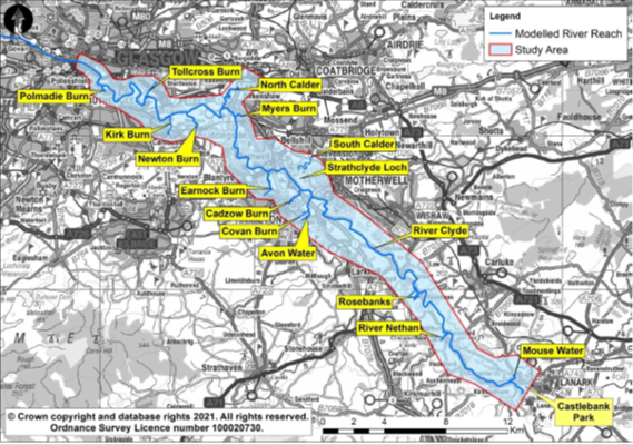
The study area extends from the Falls of Clyde near Lanark to the A77 Road Bridge in Glasgow City Centre, covering approximately 60km of the River Clyde watercourse. The model itself extends beyond the study area to permit overlap with adjacent downstream (tidal) river model. The model starts close to Castlebank Park near Lanark, and the downstream extent of the model is close to the confluence of the River Cart with the River Clyde.
There are 14 tributaries along the length of the River Clyde that have been included in themodel, and it the model also includes the various flood protection embankments along the Clyde corridor and the flow control structures of the Stonebyres Hydro Power Stations, Strathclyde Loch and the Glasgow Tidal Weir.

Non-tidal River Clyde flood model study area and tributaries
The main objectives of the study were to:
- Develop an improved understanding of the flood risk and mechanisms within the study area.
- Assess the current condition and standard of protection provided by the existing flood protection schemes.
- Produce flood maps to replace the existing River Clyde Flood Risk Management Strategy (RCFRMS) flood maps.
The model will be used to assess the impacts of a range of fluvial events and climate scenarios on existing and future development along the non-tidal stretch of the river as part of the formal planning process. It will also inform the development of a number of flood studies for communities along the River Clyde.
(November 2022)

